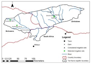
As part of a USAID-supported project on Conjunctive Water Management across borders in the SADC region, a pilot groundwater-monitoring system is being developed for the Tuli Karoo Aquifer, shared among Botswana, South Africa and Zimbabwe. This is believed to be the first time countries in sub- Saharan Africa have collaborated to install a system to actively monitor groundwater on a transboundary aquifer. The near real-time system will be applied in a set of wells in the aquifer, to provide fast and reliable groundwater levels in timely fashion. The pilot system consists of data logger with telemetry system (wireless telecommunication technology) and visualization platform. Users can access the groundwater level data via a web browser on a computer or smartphone.
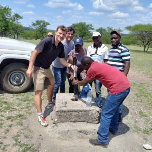
Data logger installation in Botswana with partners from the three governments of Botswana, South Africa and Zimbabwe
To advance this process, a field visit was conducted in Selebi-Phikwe, Botswana February 18-19. Participating were representatives from the three member countries, SADC-GMI, UIT, and Girma Ebrahim and Jonathan Lautze from IWMI. On 18 February (day 1), participants discussed and debated the monitoring design plan. Decisions were reached on key parameters such as criteria for prioritizing boreholes to be monitored, frequency of data recording and transmission as well as practical issues such as coping with attempts at equipment vandalism. On 19 February (day 2), participants visited a borehole and installed a data logger. Participants then returned to the hotel to engage with the online platform.
Following the meeting, Girma Ebrahim and his counterpart from Botswana began a hydro-census of the aquifer. The hydro-census was conducted to assess the suitability of the borehole for instrumentation. During the four-day hydro-census (February 21-24), 23 observation boreholes were visited. Data captured during the hydro census include: geographic coordinate, depth to groundwater, casing height, network signal strength, aquifer type, land use/land cover, sources of contamination or pumping boreholes in the vicinity (if any), and accessibility. The results of the hydro census guide the selection of observation boreholes for installation of near real-time monitoring system.